


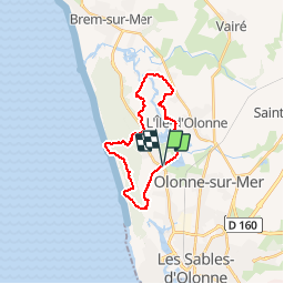
Rando Dudu85 du 23-03-2019

dudu85
User

Length
21 km

Max alt
17 m

Uphill gradient
102 m
Km-Effort
22 km

Min alt
-2 m

Downhill gradient
101 m
Boucle
Yes
Creation date :
2019-03-27 20:01:33.392
Updated on :
2019-03-27 20:02:29.125
4h53
Difficulty : Very difficult

FREE GPS app for hiking
 SityTrail
IGN / Geographical institutes
SityTrail Plus
The world is yours!
About
Trail Walking of 21 km to be discovered at Pays de la Loire, Vendée, Les Sables-d'Olonne. This trail is proposed by dudu85.
Positioning
Country:
France
Region :
Pays de la Loire
Department/Province :
Vendée
Municipality :
Les Sables-d'Olonne
Location:
Olonne-sur-Mer
Start:(Dec)
Start:(UTM)
592232 ; 5155046 (30T) N.
Comments